stories
Natural History
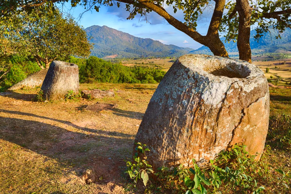
Plain of Jars
The Plain of Jars (Lao: ທົ່ງໄຫຫິນ Thong Hai Hin, [tʰōŋ hǎj hǐn]) is a megalithic archaeological landscape in Laos. It consists of thousands of stone jars scattered around the upland valleys and the lower foothills of the central plain of the Xiangkhoang Plateau. The jars are arranged in clusters ranging in number from one to several hundred.[1] The Xiangkhoang Plateau is at the northern end of the Annamese Cordillera, the principal mountain range of Indochina. French researcher Madeleine Colani concluded in 1930 that the jars were associated with burial practices. Excavation by Lao and Japanese archaeologists in the intervening years has supported this interpretation with the discovery of human remains, burial goods and ceramics around the jars. Researchers (using optically stimulated luminescence) determined that the jars were put in place as early as 1240 to 660 BC.[2] The jars at Site 1 (using detrital zircon geochronology) were determined to have been transported to their current location from a presumed quarry eight kilometers away.[2] The Plain of Jars is one of the most important prehistoric sites in Southeast Asia.
Buddha Statue
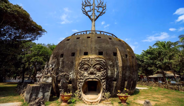
Buddha Park
Buddha Park, also known as Xieng Khuan (as well as other variations of the spelling), is a sculpture park 25 km southeast from Vientiane, Laos in a meadow by the Mekong River.[1][2] Although it is not a temple (Wat), it may be referred to as Wat Xieng Khuan (Lao: ວັດຊຽງຄວນ;Thai: วัดเซียงควน) since it contains numerous religious images.[3] The name Xieng Khuan means Spirit City.[2] The park contains over 200 Hindu and Buddhist statues.[4] The socialist government operates Buddha Park as a tourist attraction and public park.
Natural History
Bolaven Plateau
The Bolaven Plateau is an elevated region in southern Laos. Most of the plateau is located within Champasak Province of Laos, though the edges of the plateau are also located in Salavan, Sekong and Attapeu Provinces. It is located between the Annamite Range, along which runs Laos' eastern border with Vietnam, and the Mekong River to the west, at about 15°N 106°E. The plateau's elevation ranges approximately from 1,000 to 1,350 metres (3,280 to 4,430 ft) above sea level. The plateau is crossed by several rivers and has many scenic waterfalls. The name Bolaven makes reference to the Laven ethnic group which has historically dominated the region. However, domestic migrations by the Lao ethnic group (which comprises approximately 50 to 60 percent of the population of Laos) has resulted in widespread interethnic marriage, thus modifying the ethnic composition of the region.
Buddha Statue
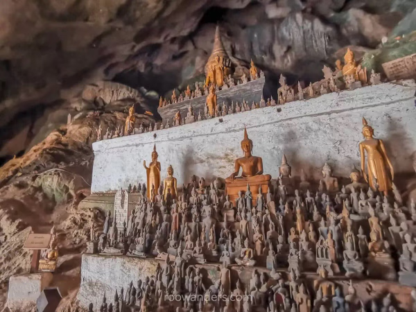
Pak Ou Caves
Near Pak Ou (mouth of the Ou river) the Tham Ting (lower cave) and the Tham Theung (upper cave) are caves overlooking the Mekong River, 25 km to the north of Luang Prabang, Laos. They are a group of two caves on the west side of the Mekong river, about two hours upstream from the centre of Luang Prabang, and are frequently visited by tourists.
Warfare-related
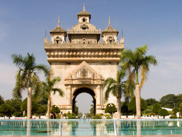
Patuxai
Patuxai (Lao: ປະຕູໄຊ; literally Victory Gate or Gate of Triumph, formerly the Anousavary or Anosavari Monument, known by the French as Monument Aux Morts) is a war monument in Downtown Vientiane, Laos, built between 1957 and 1968. The Patuxai was dedicated to those who fought in the struggle for independence from France. In romanizing the name from the Laotian language, it is variously transliterated as Patuxai, Patuxay, Patousai and Patusai. It is also called Patuxai Arch or the Arc de Triomphe of Vientiane as it resembles the Arc de Triomphe in Paris. However, it is typically Laotian in design, decorated with mythological creatures such as the kinnari (half-female, half-bird).
Natural History
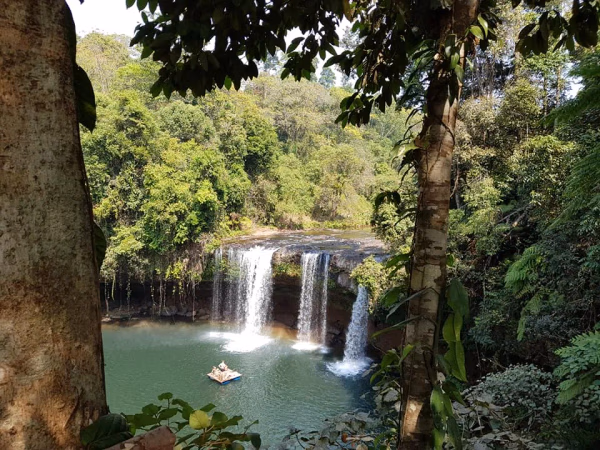
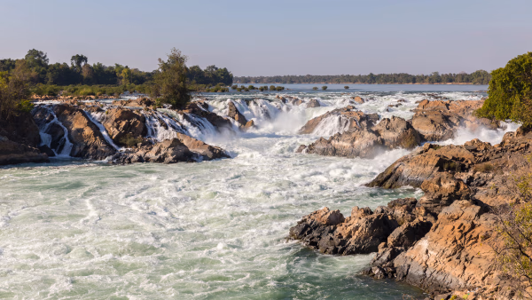
Khone Phapheng Falls
The Khone Falls and Pha Pheng Falls (Lao: ນ້ຳຕົກຕາດຄອນພະເພັງ; Khmer: ល្បាក់ខោន, Lbak Khaon) together form a waterfall located in Champasak Province on the Mekong River in southern Laos, near the border with Cambodia. It is the widest waterfall in the world at 10,783 metres (35,376 feet or 6.7 miles) in width from one edge of its multiple channels to the other.
Natural History
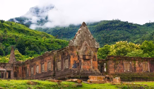
Vat Phou
Vat Phou (or Vat Phu; Lao: ວັດພູ [wāt pʰúː] temple-mountain) is a ruined Khmer Hindu temple complex in southern Laos and one of the oldest places of worship in Southeast Asia. It is at the base of mount Phou Khao, some 6 kilometres (3.7 mi) from the Mekong in Champasak Province. There was a sanctuary on the site centred on a sacred spring and an offering place for a mighty tutelary sprit dating back to pre-historic times. The first megalithic stone structures had been built probably as early as the second century BCE, consisting of two stone cells, a carving of a crocodile, a serpent stairs and several offering platforms.[1] One of the first pre-Angkor brick buildings onsite was erected in the early 7th century and became the focus of all consequent building activities.[1] Most of the other surviving buildings date from the Angkor period in the 11th to 13th centuries.
Natural History
Phabath Phonesan Stupa
This is the most significant event of Bolikhamxay Province when they celebrate the old stupa and give respect to Buddha’s footprint in Thaphabath District. The festival is held over three to seven days during the full moon of the second lunar month (January). The festival includes a Buddhist ceremony, trade fairs, concert and fun fairs arranged around the grounds of the stupa.
Natural History
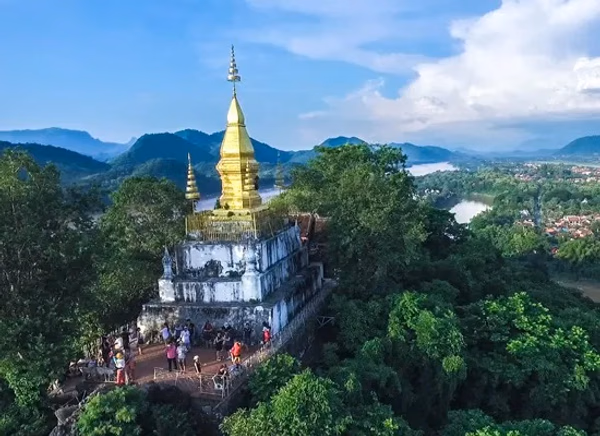
Phou Si
Mount Phou Si, also written Mount Phu Si, is a 100 m (328 ft) high hill in the centre of the old town of Luang Prabang[1] in Laos. It lies in the heart of the old town peninsula and is bordered on one side by the Mekong River and on the other side by the Nam Khan River. The hill is a local religious site, and houses several Buddhist shrines. Halfway up the hill, overlooking the Nam Khan is Wat Tham Phou Si, a Buddhist temple. At the summit of the hill, overlooking the town and surrounding countryside, is Wat Chom Si, which is also a Buddhist temple and is a tourist highlight of Luang Prabang. Entrance to Phou Si is 20,000 Kip as of July 2018
Natural History
Pakse
Pakse (or Pakxe; French: Paksé; Laotian: ປາກເຊ [pȁːk séː] 'mouth of the river'; Thai: ปากเซ) is the capital and most populous city of the southern Laotian province of Champasak. Located at the confluence of the Xe Don and Mekong Rivers, it has a population of about 95,000.[1] Pakse was the capital of the Kingdom of Champasak until it was unified with the rest of Laos in 1946.
Natural History
The Beautiful Natural Landscapes of Laos
Laos, a landlocked country in Southeast Asia, offers breathtaking natural landscapes that captivate travelers. From lush forests and vast rivers to diverse wildlife, Laos' natural beauty is a true gift of nature. This article introduces some of the most iconic natural sceneries in Laos, vividly conveyed through photos and videos.
Natural History
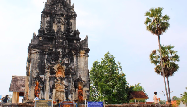
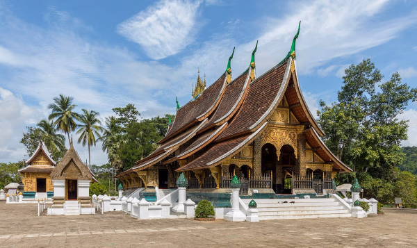
Wat Xieng Thong
Wat Xieng Thong (Lao: ວັດຊຽງທອງ, pronounced [wāt síaŋ.tʰɔ́ːŋ]; "Temple of the Golden City") is a Buddhist temple (vat or wat) on the northern tip of the peninsula of Luang Prabang, Laos.[1]: 264 Built between 1559 and 1560 by King Setthathirath, Wat Xieng Thong is one of the most important of Lao monasteries and remains a significant monument to the spirit of religion, royalty and traditional art.
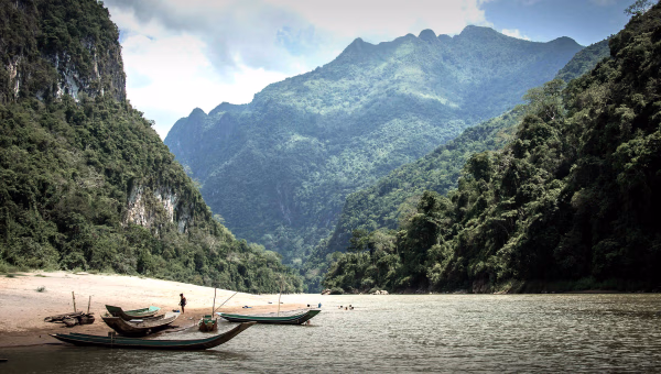
Natural History
Mekong
The Mekong or Mekong River is a trans-boundary river in East Asia and Southeast Asia. It is the world's twelfth-longest river and the third-longest in Asia[1] with an estimated length of 4,909 km (3,050 mi)[1] and a drainage area of 795,000 km2 (307,000 sq mi), discharging 475 km3 (114 cu mi) of water annually.[
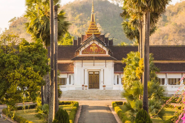
Natural History
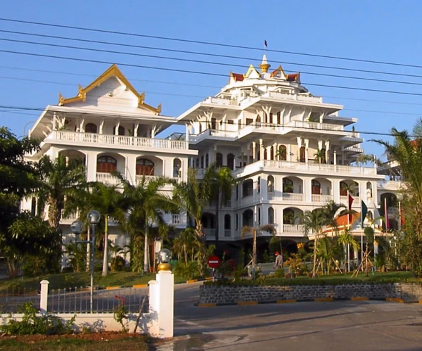
Royal Palace, Luang Prabang
The Royal Palace (official name Haw Kham, Lao: ຫໍຄຳ Lao pronunciation: [hɔ̌ɔ.kʰám]) in Luang Prabang, Laos, was built in 1904 during the French colonial era for King Sisavang Vong and his family. The site for the palace was chosen so that official visitors to Luang Prabang could disembark from their river voyages directly below the palace and be received there. After the death of King Sisavang Vong, the Crown Prince Savang Vatthana and his family were the last to occupy the grounds. In 1975, the monarchy was overthrown by the communists and the royal family were taken to re-education camps. The palace was then converted into a national museum.
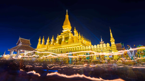
Natural History
Pha That Luang
Pha That Luang (Lao: ທາດຫຼວງ or ພຣະທາດຫລວງ; pronounced [pʰā.tʰâːt lǔa̯ŋ] 'Great Stupa') is a gold-covered large Buddhist stupa in the centre of the city of Vientiane, Laos.[1] Since its initial establishment, suggested to be in the 3rd century AD, the stupa has undergone several reconstructions as recently as the 1930s due to foreign invasions of the area. It is generally regarded as the most important national monument in Laos and a national symbol.