Mekong
The Mekong
Published 2024.08.07 by reafla powered by REAFLA
ອະທິບາຍ
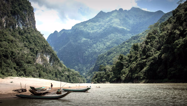
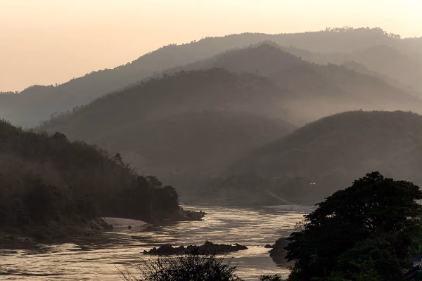
The Mekong or Mekong River is a trans-boundary river in East Asia and Southeast Asia. It is the world's twelfth-longest river and the third-longest in Asia[1] with an estimated length of 4,909 km (3,050 mi)[1] and a drainage area of 795,000 km2 (307,000 sq mi), discharging 475 km3 (114 cu mi) of water annually.[
The Mekong or Mekong River is a trans-boundary river in East Asia and Southeast Asia. It is the world's twelfth-longest river and the third-longest in Asia[1] with an estimated length of 4,909 km (3,050 mi)[1] and a drainage area of 795,000 km2 (307,000 sq mi), discharging 475 km3 (114 cu mi) of water annually.[2] From its headwaters in the Tibetan Plateau, the river runs through Southwest China (where it is officially called the Lancang River), Myanmar, Laos, Thailand, Cambodia, and southern Vietnam. The extreme seasonal variations in flow and the presence of rapids and waterfalls in the Mekong make navigation difficult. Even so, the river is a major trade route between Tibet and Southeast Asia. The construction of hydroelectric dams along the Mekong in the 2000s through the 2020s causes serious problems for the river's ecosystem, including the exacerbation of drought.
The Mekong was originally called Mae Nam Khong from a contracted form of Tai shortened to Mae Khong.[6] In Thai and Lao, Mae Nam ("Mother of Water[s]") is used for large rivers and Khong is the proper name referred to as "River Khong". However, Khong is an archaic word meaning "river", loaned from Austroasiatic languages, such as Vietnamese sông (from *krong) and Mon kruŋ "river", which led to Chinese 江 whose Old Chinese pronunciation has been reconstructed as /*kˤroŋ/[7] and which long served as the proper name of the Yangtze before becoming a generic word for major rivers. To the early European traders, the Mekong River was also known as Mekon River, May-Kiang River and Cambodia River.
The local names for the river include:
From Tai:
Thai: แม่น้ำโขง, [mɛ̂ː náːm kʰǒːŋ], or just 'แม่โขง' [mɛ̂ː kʰǒːŋ].
Lao: ແມ່ນ້ຳຂອງ, [mɛː nâːm kʰɔːŋ], ນ້ຳຂອງ [nâːm kʰɔːŋ].
Tai Lue: น้ำแม่ของ [nâːm mɛː kʰɔ̌ːŋ], น้ำของ [nâːm kʰɔ̌ːŋ].
Khmer: មេគង្គ Mékôngk [meːkɔŋ], ទន្លេមេគង្គ Tônlé Mékôngk [tɔnlei meikɔŋ].
Burmese: မဲခေါင်မြစ်, IPA: [mɛ́ɡàʊɰ̃ mjɪ̰ʔ].
Shan: ၼမ်ႉၶွင် [nâm.kʰɔ̌ŋ] or ၼမ်ႉမႄႈၶွင် [nâm.mɛ.kʰɔ̌ŋ].
Chinese: 湄公河; Méigōng hé.
Vietnamese: Sông Mê Kông (IPA: [ʂə̄wŋm mē kə̄wŋm]).
Other:
Vietnamese: Sông Cửu Long, (九龍 Nine Dragons River [ʂə̄wŋm kɨ̂w lāwŋm]).
Khmer: ទន្លេធំ Tônlé Thum [tɔnlei tʰum] (lit. "Big River" or "Great River").
Khmuic: [ŏ̞m̥ kʰrɔːŋ̊], 'ŏ̞m̥' means 'river' or 'water', here it means 'river', 'kʰrɔːŋ̊' means 'canal'. So 'ŏ̞m̥ kʰrɔːŋ̊' means 'canal river'. In the ancient time Khmuic people called it '[ŏ̞m̥ kʰrɔːŋ̊ ɲă̞k̥]' or '[ŏ̞m̥ kʰrɔːŋ̊ ɟru̞ːʔ]' which means 'giant canal river' or 'deep canal river' respectively
The Mekong rises as the Za Qu (Tibetan: རྫ་ཆུ་, Wylie: rDza chu, ZYPY: Za qu; Chinese: 扎曲; pinyin: Zā Qū) and soon becomes known as the Lancang River (simplified Chinese: 澜沧江; traditional Chinese: 瀾滄江; pinyin: Láncāng Jiāng, from the old name of Lao kingdom Lan Xang; the characters may also be literally understood as "turbulent green river"). It originates in the "three rivers source area" on the Tibetan Plateau in the Sanjiangyuan National Nature Reserve. The reserve protects the headwaters of, from north to south, the Yellow (Huang He), the Yangtze, and the Mekong Rivers.[2] It flows through the Tibetan Autonomous Region and then southeast into Yunnan Province, and then the Three Parallel Rivers Area in the Hengduan Mountains, along with the Yangtze to its east and the Salween River (Nu Jiang in Chinese) to its west.
Then the Mekong meets the China–Myanmar border and flows about 10 km (6.2 mi) along that border until it reaches the tripoint of China, Myanmar and Laos. From there it flows southwest and forms the border of Myanmar and Laos for about 100 km (62 mi) until it arrives at the tripoint of Myanmar, Laos, and Thailand. This is also the point of confluence between the Ruak River (which follows the Thai–Myanmar border) and the Mekong. The area of this tripoint is sometimes termed the Golden Triangle, although the term also refers to the much larger area of those three countries that was notorious as a drug producing region.
From the Golden Triangle tripoint, the Mekong turns southeast to briefly form the border of Laos with Thailand.
Khon Pi Long is a series of rapids along a 1.6-kilometre section of the Mekong River dividing Chiang Rai and Bokeo Province in Laos. The name of the rapids means 'where the ghost lost its way'.[13] It then turns east into the interior of Laos, flowing first east and then south for some 400 km (250 mi) before meeting the border with Thailand again. Once more, it defines the Laos-Thailand border for some 850 km (530 mi) as it flows first east, passing the capital of Laos, Vientiane, then turns south. A second time, the river leaves the border and flows east into Laos soon passing the city of Pakse. Thereafter, it turns and runs more or less directly south, crossing into Cambodia.
At Phnom Penh the river is joined on the right bank by the river and lake system the Tonlé Sap. When the Mekong is low, the Tonle Sap is a tributary: water flows from the lake and river into the Mekong. When the Mekong floods, the flow reverses: the floodwaters of the Mekong flow up the Tonle Sap.
Immediately after the Sap River joins the Mekong by Phnom Penh, the Bassac River branches off the right (west) bank. The Bassac River is the first and main distributary of the Mekong. This is the beginning of the Mekong Delta. The two rivers, the Bassac to the west and the Mekong to the east, enter Vietnam shortly after this. In Vietnam, the Bassac is called the Hậu River (Sông Hậu or Hậu Giang); the main, eastern, branch of the Mekong is called the Tiền River or Tiền Giang. In Vietnam, distributaries of the eastern (main, Mekong) branch include the Mỹ Tho River, the Ba Lai River, the Hàm Luông River, and the Cổ Chiên River.
The Mekong Basin can be divided into two parts: the "upper Mekong basin" in Tibet, and the "lower Mekong basin" from Yunnan downstream from China to the South China Sea.[14] From the point where it rises to its mouth, the most precipitous drop in the Mekong occurs in the upper Mekong basin, a stretch of some 2,200 km (1,400 mi). Here, it drops 4,500 m (14,800 ft) before it enters the lower basin where the borders of Thailand, Laos, China, and Myanmar come together in the Golden Triangle. Downstream from the Golden Triangle, the river flows for a further 2,600 km (1,600 mi) through Laos, Thailand, and Cambodia before entering the South China Sea via a complex delta system in Vietnam.[14]
Upper basin
The upper basin makes up 24% of the total area and contributes 15–20% of the water that flows into the Mekong River. The catchment here is steep and narrow with Soil erosion being a major problem and as a result of this, approximately 50% of the sediment in the river comes from the upper basin.
In Yunnan Province in China, the river and its tributaries are confined by narrow, deep gorges. The tributary river systems in this part of the basin are small. Only 14 have catchment areas that exceed 1,000 km2 (390 sq mi), yet the greatest amount of loss of forest cover in the entire river system per square kilometer has occurred in this region due to heavy unchecked demand for natural resources. In the south of Yunnan, in Simao and Xishuangbanna Prefectures, the river changes as the valley opens out, the floodplain becomes wider, and the river becomes wider and slower.
Lower basin
Major tributary systems develop in the lower basin. These systems can be separated into two groups: tributaries that contribute to the major wet season flows, and tributaries that drain low relief regions of lower rainfall. The first group are left bank tributaries that drain the high rainfall areas of Laos. The second group are those on the right bank, mainly the Mun and Chi Rivers, that drain a large part of northeast Thailand.
Laos lies almost entirely within the lower Mekong basin. Its climate, landscape and land use are the major factors shaping the hydrology of the river. The mountainous landscape means that only 16% of the country is farmed under lowland terrace or upland shifting cultivation.[14] With upland shifting agriculture (slash and burn), soils recover within 10 to 20 years but the vegetation does not. Shifting cultivation is common in the uplands of northern Laos and is reported to account for as much as 27% of the total land under rice cultivation.[14] As elsewhere in the basin, forest cover has been steadily reduced during the last three decades by shifting agriculture and permanent agriculture. The cumulative impacts of these activities on the river regime have not been measured. However, the hydrological impacts of land cover changes induced by the Vietnam War were quantified in two sub-catchments of the lower Mekong River basin.[15]
Loss of forest cover in the Thai areas of the lower basin has been the highest of all the lower Mekong countries over the past 60 years. On the Khorat Plateau, which includes the Mun and Chi tributary systems, forest cover was reduced from 42% in 1961 to 13% in 1993.[14] Although this part of northeast Thailand has an annual rainfall of more than 1,000 mm, a high evaporation rate means it is classified as a semi-arid region. Consequently, although the Mun and Chi basins drain 15% of the entire Mekong basin, they only contribute 6% of the average annual flow.[14] Sandy and saline soils are the most common soil types, which makes much of the land unsuitable for wet rice cultivation. In spite of poor fertility, however, agriculture is intensive. Glutinous rice, maize, and cassava are the principal crops.[14] Drought is by far the major hydrological hazard in this region.
As the Mekong enters Cambodia, over 95% of its flows have already joined the river.[14] From here on downstream the terrain is flat and water levels rather than flow volumes determine the movement of water across the landscape. The seasonal cycle of changing water levels at Phnom Penh results in the unique "flow reversal" of water into and out of the Great Lake via the Tonle Sap River. Phnom Penh also marks the beginning of the delta system of the Mekong River. Here the mainstream begins to break up into an increasing number of branches.[14]
In Cambodia, wet rice is the main crop and is grown on the flood plains of the Tonle Sap, Mekong, and Bassac (the Mekong delta distributary known as the Hậu in Vietnam) Rivers.[14] More than half of Cambodia remains covered with mixed evergreen and deciduous broadleaf forest, but forest cover has decreased from 73% in 1973 to 63% in 1993.[14] Here, the river landscape is flat. Small changes in water level determine the direction of water movement, including the large-scale reversal of flow into and out of the Tonle Sap basin from the Mekong River.
The Mekong Delta in Vietnam is farmed intensively and has little natural vegetation left. Forest cover is less than 10%. In the Central Highlands of Vietnam, forest cover was reduced from over 95% in the 1950s to around 50% in the mid-1990s.[14] Agricultural expansion and population pressure are the major reasons for land use and landscape change. Both drought and flood are common hazards in the Delta, which many people believe is the most sensitive to upstream hydrological change.
ປະເພດກ່ຽວຂ້ອງ
Natural History
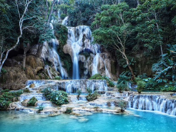
Kuang Si Waterfall: A Natural Wonder of Laos
We explore the beauty of Kuang Si Waterfall in Laos and the experiences it offers to travelers who visit it.
Natural History
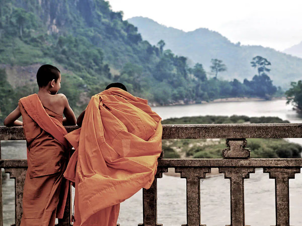
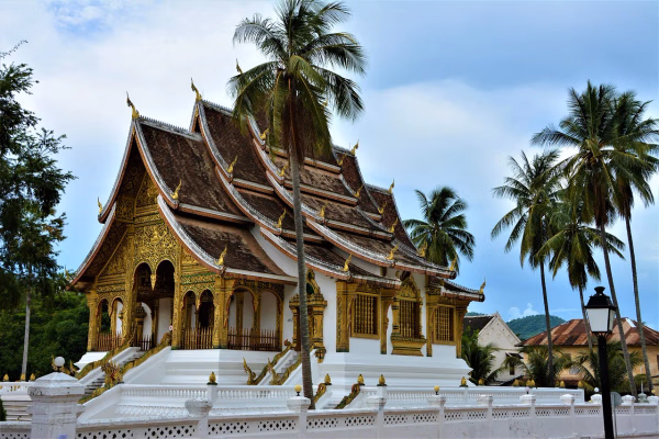
Luang Prabang
Luang Phabang, (Lao: ຫລວງພະບາງ/ຫຼວງພະບາງ) or Louangphabang (pronounced [lǔaŋ pʰa.bàːŋ]), commonly transliterated into Western languages from the pre-1975 Lao spelling ຫຼວງພຣະບາງ (ຣ = silent r) as Luang Prabang, literally meaning "Royal Buddha Image", is a city in north central Laos, consisting of 58 adjacent villages, of which 33 comprise the UNESCO Town of Luang Prabang World Heritage Site. It was listed in 1995 for unique and "remarkably" well preserved architectural, religious and cultural heritage, a blend of the rural and urban developments over several centuries, including the French colonial influences during the 19th and 20th centuries.
Natural History
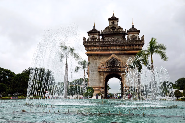
Vientiane
Vientiane (/viˌɛntiˈɑːn/ vee-EN-tee-AHN,[3] French: [vjɛ̃tjan]; Lao: ວຽງຈັນ, Viangchan, pronounced [wía̯ŋ t͡ɕàn]) is the capital and largest city of Laos. Comprising the five urban districts of Vientiane Prefecture, the city is located on the banks of the Mekong, right at the border with Thailand. Vientiane was the administrative capital during French rule and, due to economic growth in recent times, is now the economic center of Laos. The city had a population of 1,001,477 as of the 2023 Census. Vientiane is the home of the most significant national monuments such as Pha That Luang, a national symbol of Laos and an icon of Buddhism in Laos. Other significant Buddhist temples can be found there as well, such as Haw Phra Kaew, which formerly housed the Emerald Buddha. The city hosted the 25th Southeast Asian Games in December 2009, celebrating 50 years of the games.