UNESCO World Heritage
Vat Phou-Champasak Site
Published 2024.08.14 by 유다연
ອະທິບາຍ
A Great Collaboration Created by the Harmony of Man and Nature
UNESCO World Heritage sites hold exceptional significance and “outstanding universal value” for present and future generations of humanity. UNESCO recognizes the associative values of tangible/intangible heritage and landscapes; “cultural landscapes” have been inscribed on the World Heritage List since 1992. To date, more than a hundred sites around the world have been inscribed as cultural landscapes. UNESCO designated “Vat Phou and Associated Ancient Settlements within the Champasak Cultural Landscape” as a World Heritage Site in 2001.
Cultural landscapes are sites representing the “combined works of nature and man.” They express a long and sustainable relationship between humans and their natural environment. Certain sites reflect the specific techniques of land use or man’s spiritual relationship with nature, which has guaranteed bio-diversity.
Heritage sites inscribed as cultural landscapes often maintain a close, long-standing interaction between humans and their surrounding environment. Practices such as the community's eco-friendly agriculture and traditional nature-worship rituals are preserved in their original or similar forms, ensuring biodiversity. Paradoxically, t he Vat Phou-Champasak site is both well-known and almost unknown. Its historical value makes it well-known among a few experts, but it remains unfamiliar to the general public. The entire site is a grand artistic creation that reinterprets the sacred sites of ancient traditional beliefs using the Hindu worldview. The cultural heritage from the Khmer Empire and post-Khmer periods harmoniously integrates with the natural landscape to form a sacred ceremonial landscape. The symphony created by the collaboration of tangible and intangible human cultural activities and nature is a remarkable masterpiece rarely seen at any other heritage site in the world.
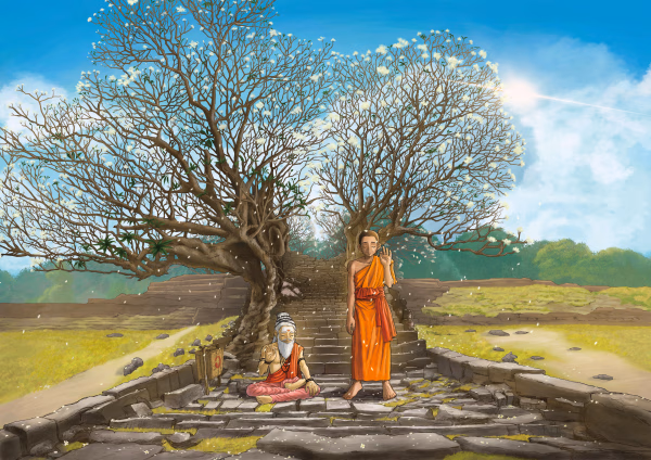
Originally built as a Hindu temple, it is now used as a Buddhist temple. The illustration depicts the coexistence of the past and present by showing a Hindu ascetic and a Buddhist monk together.
The Landmark Mountain of Linga, Lingaparvata
Around the 5th to 6th centuries, a city modeled after Kurukshetra, the legendary sacred capital of ancient India, was established on the western bank of the Mekong River. The locals believed that a towering 10-meter-high stone pillar at the peak of one of the Phou Kao mountain range's mountains was a manifestation of Shiva in the form of a linga, and they named this mountain 'Lingaparvata,' the Mountain of Linga. This mountain became a central landmark in the sacred landscape. Just as the sacred Ganges River is said to originate from Mount Kailash in the Himalayas and flow through the hair of Shiva, the locals revered the Mekong River—where tributaries originating from the Mountain of Linga converge—as a sacred river. The forest, mountain ridges, and lands spreading between the divine mountain peak and the life-giving river were regarded as an ideal Hindu realm.
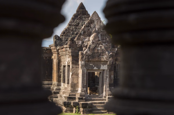
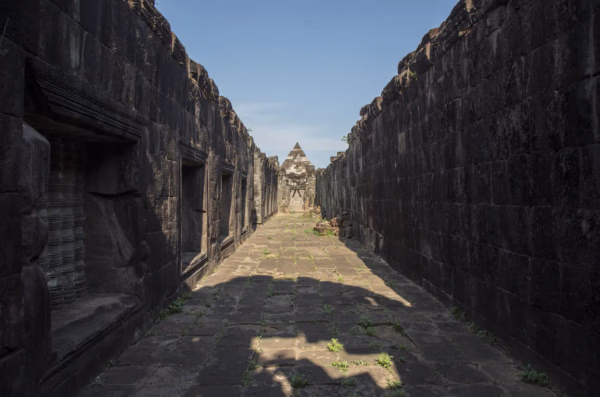
The Vat Phou temple complex, dedicated to the worship of Shiva, was constructed along the path from the ridge of Lingaparvata down to the Mekong River. The landscape, featuring the giant linga at the mountain peak symbolizing 'the world of gods,' the main sanctuary of Vat Phou, the ridges and forest representing 'the world of saints,' the city and land representing 'the world of humans,' and the Mekong River symbolizing 'the ocean of the universe,' evokes the Hindu cosmological map, the Mandala.
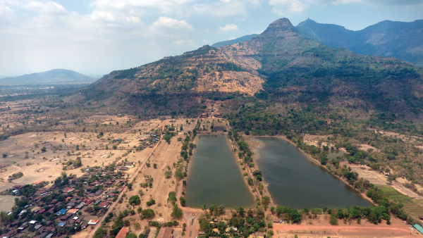
The sacred mountain's forest, filled with holy rocks, waterfalls, valleys, caves, and ancient trees, is rich with traces of local beliefs and the practices of Hindu sages, including yoga and meditation. This forest, with its life-giving water flowing through valleys and tributaries to nourish the land, provides the locals with essential resources such as timber, stone, fruits, and medicinal herbs necessary for construction and daily life. The locals developed canals and barays using the tributaries flowing from the sacred mountain, and the surplus production from managing these water resources was used to support the construction and maintenance of temples and public facilities.
ການນິດສະການທີ່ກ່ຽວຂ້ອງ

Natural History
Online Exhibition of the Vat Phou Champasak Ruins and the Excavation of Hong Nang Sida
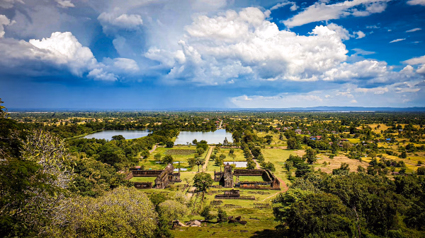
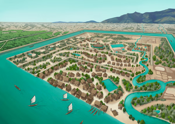
The Vat Phou - Champasak site lies on fertile alluvial plains on the banks of the Mekong River, and its mountainous core is the eastern outlier of the Dângrêk Range, which is home to the Phou Kao Mountains that rise up to an altitude of 1,416 meters.
Natural History
Lao-Korea Cooperation Project : Hong Nang Sida Temple
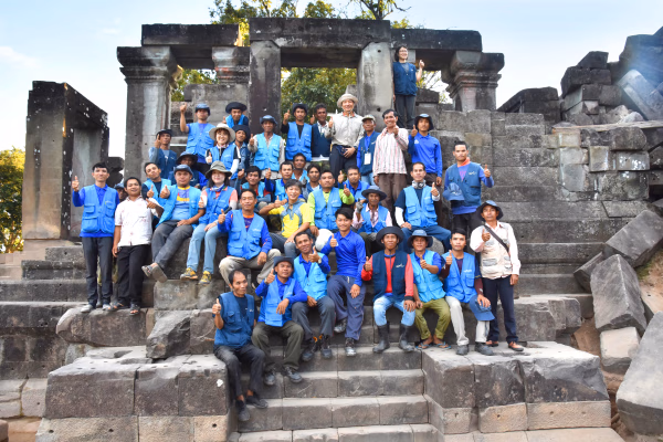
Since 2013, the Cultural Heritage Administration and the Korea Cultural Heritage Foundation have been working on a heritage restoration project at the World Heritage Site “Vat Phou and Associated Ancient Settlements within the Champasak Cultural Landscape” in Lao PDR. The project focuses on restoring the collapsed stone structure called Hong Nang Sida, located in the southern part of the Vat Phou Temple Complex. This site, also known as the “Temple of Princess Sida,” is gradually regaining its original appearance thanks to the ongoing restoration efforts by a Korean research team.
Natural History
Sacred River
The archaeological site of the ancient city is situated on the plains adjacent to the Mekong River. The city was surrounded by two layers of brick and earthen ramparts, with a moat in between. These ramparts measured approximately 2.4 km from north to south and 1.8 km from east to west, with the best-preserved sections standing up to 6 meters high and 14 meters thick. The walls and moats were likely constructed to manage and utilize the waters from the Phou Kao Mountains' tributaries.